📞 07740 251154 | admin@ercsinternational.com | Office Time: Mon-Fri: 08:30 – 17:30

ERCS International Ltd
  • Home
  • Drone Survey
    • Drone Surveys Overview
    • UXO Survey
    • Land Surveys
    • Volume Survey
    • Boundary Survey
    • Topographic Survey
    • Progress Monitoring
    • UAV Roof Inspections
    • Aerial 3D Modeling Survey
    • Drone Surveys For Housing
    • About Our UAV Division
  • Drone Technologies
    • Drone Technology Overview
    • LiDAR
    • Multibeam
    • Magnetometry
    • Data Visualisation
    • Ground Penetrating Radar
    • Photogrammetry Processing
  • About US
    • Contact
    • Our Partners
    • FAQ
    • Blog
    • Offshore & Nearshore
    • Survey Consultancy
  • More
    • Home
    • Drone Survey
      • Drone Surveys Overview
      • UXO Survey
      • Land Surveys
      • Volume Survey
      • Boundary Survey
      • Topographic Survey
      • Progress Monitoring
      • UAV Roof Inspections
      • Aerial 3D Modeling Survey
      • Drone Surveys For Housing
      • About Our UAV Division
    • Drone Technologies
      • Drone Technology Overview
      • LiDAR
      • Multibeam
      • Magnetometry
      • Data Visualisation
      • Ground Penetrating Radar
      • Photogrammetry Processing
    • About US
      • Contact
      • Our Partners
      • FAQ
      • Blog
      • Offshore & Nearshore
      • Survey Consultancy

  • Home
  • Drone Survey
    • Drone Surveys Overview
    • UXO Survey
    • Land Surveys
    • Volume Survey
    • Boundary Survey
    • Topographic Survey
    • Progress Monitoring
    • UAV Roof Inspections
    • Aerial 3D Modeling Survey
    • Drone Surveys For Housing
    • About Our UAV Division
  • Drone Technologies
    • Drone Technology Overview
    • LiDAR
    • Multibeam
    • Magnetometry
    • Data Visualisation
    • Ground Penetrating Radar
    • Photogrammetry Processing
  • About US
    • Contact
    • Our Partners
    • FAQ
    • Blog
    • Offshore & Nearshore
    • Survey Consultancy

Volume Surveys

Accurate Volume Measurements from Stockpiles to Quarries

Using Advanced Drone and Digital Survey Technology for Precise Results

From small stockpiles to large quarry excavations, ERCS International delivers accurate volume measurements using land survey data, captured via advanced drone technology and the latest in post processing software suites. With extensive experience serving major construction clients, we are committed to providing reliable, professional surveying services tailored to your project’s needs. 


Measure with confidence. Trust ERCS International for precise volume surveys powered by our advanced drone technology. Let’s elevate your project today! 

Drone Technology

ERCS use leading GPS corrections providers, photogrammetry, LiDAR, and drone technology, we quickly and safely collect accurate site data, even in challenging environments.


Contact ERCS International today to learn more about our volume surveys

Reach out to Learn More

The Benefits of Volume Surveys

Accurate volume surveys are critical, getting them wrong can cost millions in wasted materials, project delays, and compliance penalties. At ERCS International, we provide precise volume measurements that enable better budgeting and resource management, helping clients avoid costly errors. This accuracy is essential for industries such as mining, construction, and waste management, where regulatory compliance and exact reporting are mandatory.


We also prioritise safety by using advanced UAV/drone technology to conduct remote surveys in hazardous environments like quarries and landfills. This approach not only increases data collection efficiency but also significantly reduces risks to personnel, ensuring safer, faster, and more reliable volume surveys.

Faster, Safer, and More Accurate Surveying Benefits

ERCS International uses drone LiDAR, photogrammetry and advanced GPS correction providers to deliver efficient, precise volume and land surveys, even in challenging environments.   

Get a quote

Useful Content

Land Surveys Overview

Land Surveys Overview

Land Surveys Overview

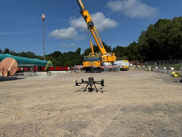
 ERCS International offers a range of specialist land surveys, including topographic surveys, progress and volumetric surveys, and detailed site mapping using UAV, LiDAR, photogrammetry, and ground-penetrating radar. These services provide precise, up-to-date data to support planning, construction monitoring, and infrastructure development. 

Our Land Surveys

Our Technologies

Land Surveys Overview

Land Surveys Overview

 ERCS International uses advanced technologies including UAV-based aerial surveying, LiDAR, photogrammetry, and ground-penetrating radar. These methods deliver highly accurate, detailed data for site mapping, progress monitoring, and subsurface investigation, helping clients make informed decisions and manage projects more effectively.  

Our Technologies

Drone Survey

Drone Technology

Drone Technology

Drone Survey Overview

Topographical Survey

Arial 3D Survey

Land Survey

Volume Survey

Progress Monitoring Survey

Drone Survey For Housing

UAV Roof Survey

UXO Survey

Boundary Survey

Drone Technology

Drone Technology

Drone Technology

Drone Technology Overview

Multibeam 

Ground Penetrating Radar

Photogrammetry Processing

Data visualisation

LiDAR

Magnetometry

About Us

Drone Technology

About Us

Contact Us

Our Partners

FAQ

Blog

Offshore & Nearshore

Overview to Survey Consultancy


Copyright © 2025 ERCS International Ltd - All Rights Reserved.

  • Drone Technology Overview
  • Offshore & Nearshore
  • Privacy Policy

This website uses cookies.

We use cookies to analyze website traffic and optimize your website experience. By accepting our use of cookies, your data will be aggregated with all other user data.

DeclineAccept