📞 07740 251154 | admin@ercsinternational.com | Office Time: Mon-Fri: 08:30 – 17:30
ERCS International delivers precise boundary surveys tailored for housing and construction projects. Utilising a combination of LiDAR and photogrammetry, we capture highly accurate spatial data that can be overlaid onto 2D and 3D models, creating detailed digital twins. This enables seamless comparison with land registry records, ensuring clarity and accuracy for property boundaries.
We provide survey data in various client-preferred formats and offer expert data interpretation through our trusted partner network, going beyond basic processing to deliver actionable insights.
This boundary drone survey data can be used to create accurate topographic maps and detailed digital twin models.
ERCS employs advanced drone mounted LiDAR and photogrammetry systems to efficiently gather boundary data, even in complex or challenging environments.
Contact ERCS International today to learn how our boundary surveys can support your project needs.
Accurate boundary surveys are essential to prevent costly disputes, ensure legal compliance, and support clear property delineation. At ERCS International, our precise surveys enable clients to make confident decisions in housing and construction projects, reducing risks related to boundary errors and ensuring smooth project delivery.
We also prioritise safety and efficiency by using advanced UAV drone technology combined with LiDAR and photogrammetry, enabling remote data collection even in complex environments. This approach not only improves accuracy but also speeds up the surveying process, delivering reliable results on time and within budget.
ERCS International’s use of cutting-edge drone technology and digital survey methods ensures faster, safer, and more accurate boundary surveys, supporting project success and legal certainty across all site conditions.
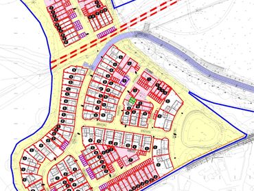
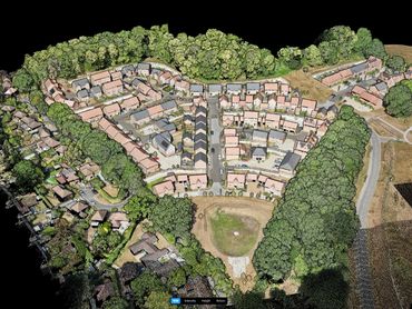
ERCS International provides specialist land surveying services, including topographic, progress, and volumetric surveys, along with high-resolution site mapping. Using advanced technologies such as UAVs, LiDAR, photogrammetry, and ground-penetrating radar, we deliver precise and current data to support project planning, construction tracking, and infrastructure development.
ERCS International employs cutting-edge technologies such as UAV aerial surveys, LiDAR, photogrammetry, and ground-penetrating radar. These approaches generate highly accurate and detailed data for site mapping, progress tracking, and subsurface analysis, enabling clients to make confident decisions and manage projects with greater efficiency.
Copyright © 2025 ERCS International Ltd - All Rights Reserved.