📞 07740 251154 | admin@ercsinternational.com | Office Time: Mon-Fri: 08:30 – 17:30

ERCS International Ltd
  • Home
  • Drone Survey
    • Drone Surveys Overview
    • UXO Survey
    • Land Surveys
    • Volume Survey
    • Boundary Survey
    • Topographic Survey
    • Progress Monitoring
    • UAV Roof Inspections
    • Aerial 3D Modeling Survey
    • Drone Surveys For Housing
    • About Our UAV Division
  • Drone Technologies
    • Drone Technology Overview
    • LiDAR
    • Multibeam
    • Magnetometry
    • Data Visualisation
    • Ground Penetrating Radar
    • Photogrammetry Processing
  • About US
    • Contact
    • Our Partners
    • FAQ
    • Blog
    • Offshore & Nearshore
    • Survey Consultancy
  • More
    • Home
    • Drone Survey
      • Drone Surveys Overview
      • UXO Survey
      • Land Surveys
      • Volume Survey
      • Boundary Survey
      • Topographic Survey
      • Progress Monitoring
      • UAV Roof Inspections
      • Aerial 3D Modeling Survey
      • Drone Surveys For Housing
      • About Our UAV Division
    • Drone Technologies
      • Drone Technology Overview
      • LiDAR
      • Multibeam
      • Magnetometry
      • Data Visualisation
      • Ground Penetrating Radar
      • Photogrammetry Processing
    • About US
      • Contact
      • Our Partners
      • FAQ
      • Blog
      • Offshore & Nearshore
      • Survey Consultancy

  • Home
  • Drone Survey
    • Drone Surveys Overview
    • UXO Survey
    • Land Surveys
    • Volume Survey
    • Boundary Survey
    • Topographic Survey
    • Progress Monitoring
    • UAV Roof Inspections
    • Aerial 3D Modeling Survey
    • Drone Surveys For Housing
    • About Our UAV Division
  • Drone Technologies
    • Drone Technology Overview
    • LiDAR
    • Multibeam
    • Magnetometry
    • Data Visualisation
    • Ground Penetrating Radar
    • Photogrammetry Processing
  • About US
    • Contact
    • Our Partners
    • FAQ
    • Blog
    • Offshore & Nearshore
    • Survey Consultancy

Aerial 3D Drone Survey

Drone Photogrammetry for Accurate 3D Mapping and Surveys

Advanced Aerial 3D Modeling with Photogrammetry and More

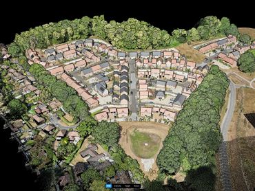
Aerial 3D modeling combines high-resolution drone imagery with sophisticated photogrammetry techniques to produce detailed and accurate spatial data. By stitching overlapping images, we create 2D orthomosaics, contour maps, digital surface models (DSMs), digital terrain models (DTMs), and full 3D models that capture every nuance of the terrain and built environment. These deliverables support precise mapping, site analysis, and project planning across industries such as construction, infrastructure, and environmental management. When paired with complementary technologies like LiDAR and multispectral sensors, this approach forms a powerful foundation for comprehensive digital twin solutions when using drone survey technology. 

Faster Insights, Smarter Decisions

Using aerial 3D modeling accelerates data collection and improves accuracy, enabling teams to visualize complex sites in both 2D and 3D. This means faster project turnaround times, better-informed decisions, and reduced risk, all while minimising the need for on-site visits and manual measurements. 

Speak to Us

Related Technologies

LiDAR Survey

Photogrammetry Processing

Photogrammetry Processing

Drone LiDAR uses laser scanning to capture precise 3D data, even through dense vegetation. It enhances survey accuracy, speeds up data collection, and supports planning, modeling, and digital twin development 


Learn More About LiDAR

Photogrammetry Processing

Photogrammetry Processing

Photogrammetry Processing

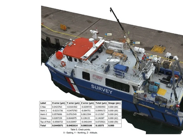
Photogrammetry transforms aerial images into accurate 3D maps and models, enabling in-depth site analysis without needing to step on site. Drone surveys accelerates data turnaround, cuts down on field visits, and delivers dependable visuals for planning and oversight 

Learn More About Photogrammetry

Drone Survey

Drone Technology

Drone Technology

Drone Survey Overview

Topographical Survey

Arial 3D Survey

Land Survey

Volume Survey

Progress Monitoring Survey

Drone Survey For Housing

UAV Roof Survey

UXO Survey

Boundary Survey

Drone Technology

Drone Technology

Drone Technology

Drone Technology Overview

Multibeam 

Ground Penetrating Radar

Photogrammetry Processing

Data visualisation

LiDAR

Magnetometry

About Us

Drone Technology

About Us

Contact Us

Our Partners

FAQ

Blog

Offshore & Nearshore

Overview to Survey Consultancy


Copyright © 2025 ERCS International Ltd - All Rights Reserved.

  • Drone Technology Overview
  • Offshore & Nearshore
  • Privacy Policy

This website uses cookies.

We use cookies to analyze website traffic and optimize your website experience. By accepting our use of cookies, your data will be aggregated with all other user data.

DeclineAccept