📞 07740 251154 | admin@ercsinternational.com | Office Time: Mon-Fri: 08:30 – 17:30

Topographic Land Surveys With Advanced Drone Technology
Topographical Surveyors
ERCS provides high-precision topographic surveys to support major development, regeneration, and infrastructure projects across the UK. From greenfield and brownfield sites to complex urban redevelopments, our team delivers detailed mapping and elevation data critical for design and planning. Using advanced UAV photogrammetry, LiDAR, and ground based GNSS technology, we ensure efficient, accurate, and reliable results to help drive informed decisions and successful project delivery during the land survey process.
Standards
ERCS delivers topographic surveys to the highest standards through our network of RICS accredited partners. Using advanced UAV, LiDAR, and ground based technologies, we provide precise, cost effective data for projects across the UK


Topographic Technologies
LiDAR Survey
RTK (Real-Time Kinematic) Precision
RTK (Real-Time Kinematic) Precision

Capture accurate topographic survey data, detailed dense point clouds, digital terrain models (DTMs), and contour maps, enabling informed land survey assessments and faster planning submissions.
RTK (Real-Time Kinematic) Precision
RTK (Real-Time Kinematic) Precision
RTK (Real-Time Kinematic) Precision
RTK (Real-Time Kinematic) positioning delivers centimetre-level accuracy in real time, essential for precise land surveying and construction tasks. By using live correction data, RTK ensures reliable, high-precision results, improving safety, efficiency, and confidence on land and coastal locations
Ground Penetrating Radar (GPR)
Ground Penetrating Radar (GPR)
Ground Penetrating Radar (GPR)
Ground Penetrating Radar (GPR) is a non-invasive geophysical method used to detect and map subsurface structures. By transmitting high-frequency radio waves into the ground and measuring the reflected signals, GPR allows ERCS International to identify buried objects, changes in material properties, voids, and other hidden features with high precision. This topographic survey technology is ideal for construction, civil engineering, and environmental projects, helping clients make informed decisions while reducing risk and minimizing excavation costs during the land survey porcess.
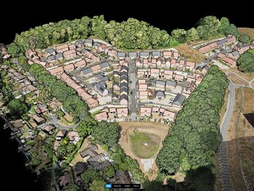
Photogrammetry
Ground Penetrating Radar (GPR)
Ground Penetrating Radar (GPR)
Photogrammetry is an advanced surveying technique that uses high-resolution aerial or ground-based photographs to create accurate 2D maps and 3D models of surfaces and structures. By analyzing overlapping images from different angles, ERCS International can generate detailed, geo-referenced representations of large areas quickly and safely. This technology supports precise measurements and visualizations for construction planning, land surveys, infrastructure monitoring, and environmental studies, providing clients with valuable data to guide critical project decisions.