📞 07740 251154 | admin@ercsinternational.com | Office Time: Mon-Fri: 08:30 – 17:30

ERCS International Ltd
  • Home
  • Drone Survey
    • Drone Surveys Overview
    • UXO Survey
    • Land Surveys
    • Volume Survey
    • Boundary Survey
    • Topographic Survey
    • Progress Monitoring
    • UAV Roof Inspections
    • Aerial 3D Modeling Survey
    • Drone Surveys For Housing
    • About Our UAV Division
  • Drone Technologies
    • Drone Technology Overview
    • LiDAR
    • Multibeam
    • Magnetometry
    • Data Visualisation
    • Ground Penetrating Radar
    • Photogrammetry Processing
  • About US
    • Contact
    • Our Partners
    • FAQ
    • Blog
    • Offshore & Nearshore
    • Survey Consultancy
  • More
    • Home
    • Drone Survey
      • Drone Surveys Overview
      • UXO Survey
      • Land Surveys
      • Volume Survey
      • Boundary Survey
      • Topographic Survey
      • Progress Monitoring
      • UAV Roof Inspections
      • Aerial 3D Modeling Survey
      • Drone Surveys For Housing
      • About Our UAV Division
    • Drone Technologies
      • Drone Technology Overview
      • LiDAR
      • Multibeam
      • Magnetometry
      • Data Visualisation
      • Ground Penetrating Radar
      • Photogrammetry Processing
    • About US
      • Contact
      • Our Partners
      • FAQ
      • Blog
      • Offshore & Nearshore
      • Survey Consultancy

  • Home
  • Drone Survey
    • Drone Surveys Overview
    • UXO Survey
    • Land Surveys
    • Volume Survey
    • Boundary Survey
    • Topographic Survey
    • Progress Monitoring
    • UAV Roof Inspections
    • Aerial 3D Modeling Survey
    • Drone Surveys For Housing
    • About Our UAV Division
  • Drone Technologies
    • Drone Technology Overview
    • LiDAR
    • Multibeam
    • Magnetometry
    • Data Visualisation
    • Ground Penetrating Radar
    • Photogrammetry Processing
  • About US
    • Contact
    • Our Partners
    • FAQ
    • Blog
    • Offshore & Nearshore
    • Survey Consultancy

Photogrammetry Processing Explained

Photogrammetry Processing for High-Resolution 3D Modelling

Creating Accurate Digital Twins from Drone Surveys

At ERCS International, photogrammetry processing plays a pivotal role in transforming aerial images captured by drones into precise 3D models and spatial data. This technology enables us to generate accurate digital twins, orthomosaics, and terrain models that support diverse projects including construction progress monitoring, environmental surveys, and infrastructure planning. Our expert team combines advanced drone platforms with powerful processing software to deliver detailed, actionable insights. 

What is Photogrammetry Processing?

Photogrammetry processing converts overlapping aerial images into detailed 3D representations of the terrain and structures. Using sophisticated algorithms, the software aligns images, generates dense point clouds, and creates textured 3D models or orthomosaics. This approach provides highly accurate spatial data essential for planning, analysis, and visualisation across various industries. 

Photogrammetry vs. Other Drone Survey Technologies

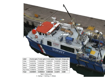
While photogrammetry uses high-resolution imagery to create 3D models, technologies like LiDAR provide precise distance measurements using laser pulses. Photogrammetry excels at capturing detailed textures and visual information, making it ideal for visualisation and surface analysis. Together, these methods complement each other, providing comprehensive data for complex survey projects. 


By producing high-resolution 3D models and maps, photogrammetry supports better decision-making and efficient project management. 

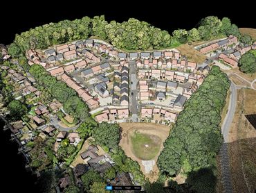
Applications of Photogrammetry in Drone Surveys

Photogrammetry is widely used in:


  • Construction progress monitoring and site documentation
  • Environmental and ecological surveys
  • Archaeological site mapping and heritage preservation
  • Utility inspections and infrastructure management

Contact Us

How ERCS International Uses Photogrammetry

ERCS International employs industry-leading drones and a variety of software platforms to process acquired survey data. Our team delivers client-ready outputs in a variety of formats tailored to specific project needs, including orthomosaics, digital surface models, and textured 3D meshes. We also offer cloud-based data sharing for easy client access and collaboration.  

Get in Touch to Learn More

Contact ERCS International today to discover how our photogrammetry processing services can enhance your surveying projects with accurate, detailed 3D models and spatial data. 

Contact Us

Drone Survey

Drone Technology

Drone Technology

Drone Survey Overview

Topographical Survey

Arial 3D Survey

Land Survey

Volume Survey

Progress Monitoring Survey

Drone Survey For Housing

UAV Roof Survey

UXO Survey

Boundary Survey

Drone Technology

Drone Technology

Drone Technology

Drone Technology Overview

Multibeam 

Ground Penetrating Radar

Photogrammetry Processing

Data visualisation

LiDAR

Magnetometry

About Us

Drone Technology

About Us

Contact Us

Our Partners

FAQ

Blog

Offshore & Nearshore

Overview to Survey Consultancy


Copyright © 2025 ERCS International Ltd - All Rights Reserved.

  • Drone Technology Overview
  • Offshore & Nearshore
  • Privacy Policy

This website uses cookies.

We use cookies to analyze website traffic and optimize your website experience. By accepting our use of cookies, your data will be aggregated with all other user data.

DeclineAccept